
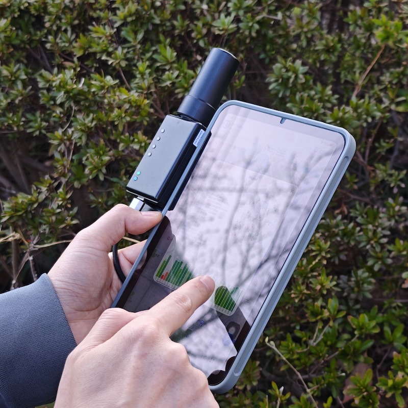
Connect a low-cost RTK receiver to your phone, over Bluetooth or a USB cable, and mark waypoints and record tracks with centimeter accuracy, with no extra license and no setup
The NANO RTK Receiver Pro, from DATAGNSS, is a small, low-cost GNSS receiver that works with GPS TrackMaker for Android starting with version 2.0. Connected to the phone over Bluetooth or a USB cable, it replaces the device’s built-in GPS and takes the accuracy of your waypoints and tracks from a few meters down to a few centimeters.
Click Approved GNSS Receivers to find out where to buy.
New to the subject? Start with the article RTK in GPS TrackMaker: from meter-level GPS to centimeter accuracy, which explains what RTK is, where the correction comes from and what you need to use it.
This page explains what the device is, what you need to use it, and how to get each app feature working with it: real-time position, corrections over the internet, waypoints and tracks in RTK, and using the NANO as your team’s base station.
Note: external GNSS receivers are supported in GPS TrackMaker for Android. As of this writing, there was no iOS version of GPS TrackMaker compatible with the NANO yet. Check the App Store to see whether the iOS version is already available.
Why we recommend the NANO
We tested several receivers before releasing version 2.0. The NANO was the one that met every requirement without any tweaking:
- RTK out of the box. It comes ready to receive corrections and reach an RTK FIXED solution. No extra license, activation or configuration needed.
- Bluetooth and USB-C. Connects to the phone wirelessly (Bluetooth LE) or by cable. Either way, the app talks to it in both directions: it receives the position and sends the corrections.
- Multi-constellation. Uses GPS, GLONASS, Galileo, BeiDou, QZSS and SBAS. Under open sky it works with 25 to 30 satellites.
- Reports real accuracy. With every position, the receiver sends its horizontal and vertical error estimates. The app shows these values on the panel and saves them in the waypoints.
- Rover and base station. The app sets up either mode with a single tap, from the Configure receiver screen.
- Size and price. It fits in your hand, weighs a few grams and costs a fraction of a traditional geodetic receiver.
Tested by the TrackMaker team with the NANO RTK Receiver v3.5 (D10P module), over Bluetooth LE and USB. In the field, under open sky and with corrections, the RTK FIXED solution stayed around 4 cm horizontally with the receiver stationary.
What you need
| Item | Notes |
|---|---|
| NANO RTK Receiver Pro with GNSS antenna | The antenna connects to the receiver’s SMA connector. Use the antenna that comes with the kit or any other multi-band GNSS antenna. |
| USB-C power | The NANO has no battery and no power button: it turns on as soon as it gets power through the USB-C port. In the field, use an ordinary power bank. Over a cable, the phone itself powers the receiver. |
| Android phone with GPS TrackMaker 2.0 or later | With Bluetooth LE (any recent Android) or with a USB-C port that accepts accessories (OTG). |
| Internet on the phone | Required to receive corrections over the internet or to broadcast as a base station. The receiver’s position, without corrections, works offline. |
| GPS TrackMaker PRO account | Connecting the receiver and using its position is free. Online Correction and Base Station require signing in with a PRO account. |
| Pole or tripod | The antenna needs to be up high, away from your body and from metal surfaces, under open sky. |
| A correction source | To get down to centimeters: a correction server over the internet (many countries have a public service, often free of charge) or your own base station broadcasting through TrackMaker. |
Setup
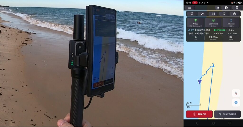
- You do not need the full kit. The NANO and the antenna attached to the phone case with Velcro are enough.
- Screw the antenna onto the receiver’s SMA connector.
- Plug the power bank into the receiver’s USB-C port. The NANO turns on right away and starts searching for satellites. Under open sky the first position appears in less than a minute.
- You can also plug the USB cable straight into the phone. The phone will then power the NANO.
- If you use a tall pole, write down the antenna height: the distance from the ground (the point you are going to measure) to the antenna, with the pole vertical.
- Enter the height value in the GPS TrackMaker app.
Tip: always use the same pole and the same height. That way you avoid getting the antenna height wrong on every outing.
Connecting the NANO to the app
The app uses one position source at a time and never switches on its own. Once you choose the NANO, it becomes the source for the map, the waypoints and the tracks until you choose another one.
Over Bluetooth (recommended in the field)
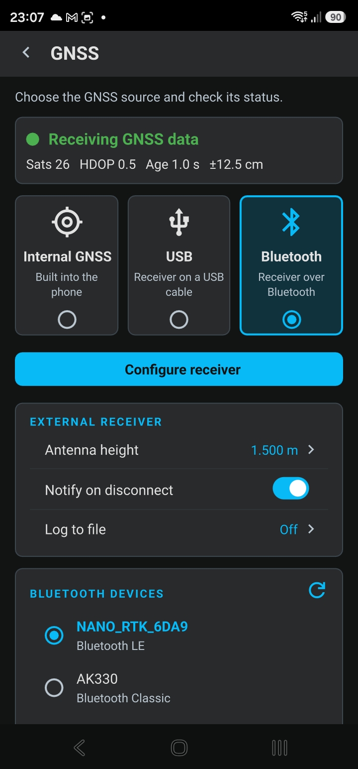
- Turn on the NANO. It advertises the name NANO_RTK_ followed by four letters or digits (e.g. NANO_RTK_6DA9).
- In the app, open the menu (☰) and tap GNSS.
- Tap the Bluetooth receiver card. The first time, Android asks for permission for the app to use Bluetooth: allow it. If Bluetooth is off, the red line Bluetooth is off. Tap to turn it on appears.
- In the BLUETOOTH DEVICES box, tap Search for receivers. Within a few seconds the NANO shows up in the list with Bluetooth LE under its name.
- Tap the NANO. The status card at the top of the page turns green: Receiving GNSS data, with the fix type, the number of satellites and the correction age.
Done. The map, the panel and the recording now use the NANO’s position.
Tip: the NANO uses Bluetooth LE and does not need to be paired in the phone settings. The pairing notice shown on the page applies only to Bluetooth Classic receivers.
The app remembers the receiver. When the app opens, or when the NANO is turned off and on again, the connection comes back on its own. A NANO accepts one phone at a time: if it does not show up in the search, check that it is not connected to another phone or to the manufacturer’s app.
Over a USB cable
- Connect the NANO to the phone with a USB-C to USB-C cable (or an OTG adapter). The phone powers the receiver through the cable.
- Android asks whether GPS TrackMaker may use the USB device. Allow it. If there is an option to remember your choice, check it.
- In the app, open the menu (☰), tap GNSS and then the USB cable receiver card.
- In the USB PORT box the NANO shows up as two ports, A and B. Choose port A. Port B is the module’s console and does not send positions (the card would stay at Connected, receiver silent).
- The speed (Speed (baud)) already comes set to 230400, which is the NANO’s. Do not change it.
Over a cable, the receiver drains the phone battery. For a full day in the field, prefer Bluetooth with the NANO on a power bank.
Going back to the phone’s GPS
On the GNSS page, tap the Internal GNSS card. Online Correction, if it is on, is turned off along with it.
Antenna height
On the GNSS page, in the EXTERNAL RECEIVER box, tap Antenna height and enter the distance from the ground to the antenna, in meters (e.g. 2.000 for a 2 m pole). The same value can be adjusted from the map’s GNSS RTK panel.
The app subtracts this height from the received altitude and saves the value used in each waypoint’s comment (ant 2.00 m). With the wrong height, the altitude of your points is off by the same amount.
Note: the altitude shown and saved by the app is the ellipsoidal height (WGS84), the same one the receiver computes. It differs from the altitude above sea level by several meters, and that is normal.
Reading the GNSS RTK panel
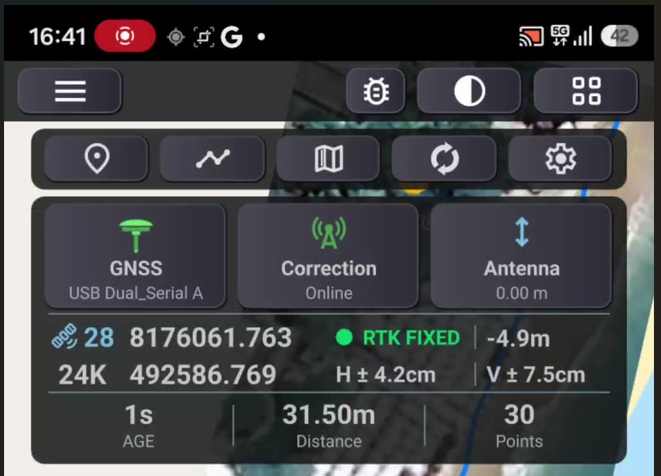
With an external receiver selected, the map’s GNSS RTK panel shows everything that matters in four lines:
| Line | What it shows |
|---|---|
| Solution type and Age | The quality of the position and the age of the last correction received, in seconds. |
| ±H ±V and satellites | Horizontal and vertical accuracy reported by the receiver and the number of satellites in use. |
| North and East | The current coordinate, in the format chosen in the settings (UTM with 3 decimals or degrees with 8 decimals). |
The solution types, from worst to best:
| Label | Meaning | Typical NANO accuracy |
|---|---|---|
| NO FIX | No position. | |
| SINGLE (yellow) | The receiver’s own position, without corrections. | 2 to 3 m |
| DGPS | Partial or stale corrections. | under 1 m |
| RTK FLOAT | Corrections applied, solution still converging. | 0.3 to 0.8 m |
| RTK FIXED (green) | Centimeter solution. This is the one that counts for measuring. | 1 to 3 cm horizontally |
Two NANO details that help interpret the numbers:
- In SINGLE and RTK FLOAT the NANO reports nominal accuracy values (always the same). Only in RTK FIXED is the reported accuracy actually computed, epoch by epoch.
- Vertical accuracy is usually two to three times the horizontal. In RTK FIXED under open sky, expect a V of a few centimeters. A V above 10 cm in FIXED is a sign that the solution is not good (see Common issues).
The Age tells you whether corrections are arriving: 1 to 2 s is normal. If it starts climbing, corrections have stopped arriving (internet, server or base station) and the solution will drop to DGPS and then SINGLE.
The header button opens the GNSS Signal window, with one bar per satellite, grouped by constellation (GPS, GALILEO, GLONASS, BEIDOU). The NANO refreshes this list every 10 seconds.
Online Correction: RTK over the internet
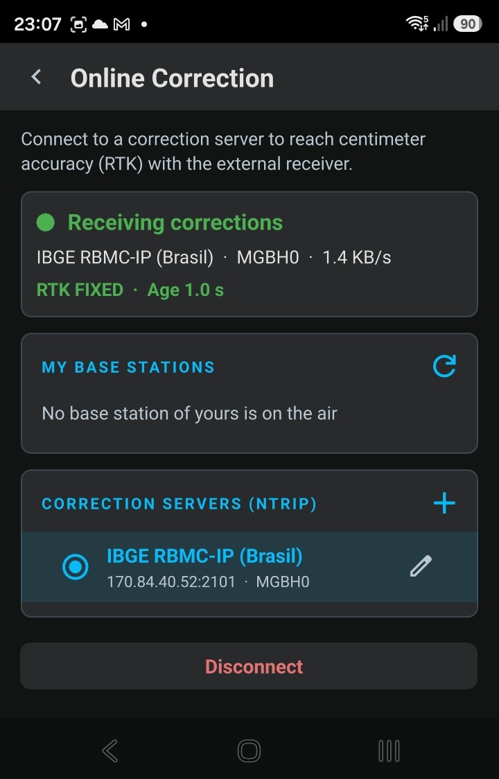
Without corrections the NANO is a good few-meter receiver. Corrections are what take the accuracy down to centimeters. The simplest path is to receive corrections from a public station over the phone’s internet, and the app delivers them to the NANO with no configuration on the receiver.
Register with the agency or service that provides corrections in your country (in many countries the national geodetic agency offers them free of charge) and keep your username and password. If that service is unreliable where you work, consider a private correction service, which usually offers better availability and coverage.
- Sign in to the app (menu ☰, Sign In) with your GPS TrackMaker PRO account.
- With the NANO connected, open the menu (☰) and tap Online Correction.
- Tap + (Add server). Choose your provider from the list, if it is there, or Enter manually to type the address and port supplied by your provider.
- In the form, check the address and port (already filled in when you pick a provider from the list) and enter the username and password from your registration.
- In Mount Point, tap the button next to the field. The app lists the provider’s stations; choose the one closest to where you work. Leave the version at V1. Tap Save.
- Tap Connect. The status card changes to Receiving corrections.
- Watch the map panel: within seconds the solution goes from SINGLE to RTK FLOAT and, under open sky, reaches RTK FIXED usually between 30 seconds and a few minutes.
Corrections keep arriving with the screen off: the app keeps a notification while Online Correction is on. If the receiver stays disconnected for 10 minutes, the correction turns itself off to save the phone battery.
Things to know:
- Distance to the station. The farther from the reference station, the slower the RTK FIXED and the larger the error: every 10 km adds about 1 cm. Beyond 50 km, FIXED may not happen at all. Always choose the closest station.
- The app opens with correction off. It is a per-session choice: when you open the app, tap Connect again.
- Switching servers disconnects. Tapping another server or station in the list turns the correction off; tap Connect to use the new one.
- Do not keep forcing reconnections. On failure, the app already retries on its own, with increasing delays. Some providers temporarily block users who reconnect too often. Service unavailable on the server means the station is down: try again later or choose another one.
- My base stations. If someone on your account is broadcasting a base station through TrackMaker, it shows up in this box, above the servers. Just tap it and then Connect (see Base Station below).
Waypoints and tracks in RTK
With the NANO in RTK FIXED, mark waypoints and record tracks as usual. The difference is in what gets recorded:
- Every waypoint marked in RTK gets, in its comment field, a line with the situation at that moment. Example:
RTK Fixed, H 0.02 m, V 0.03 m, 24 sat, age 1.0 s, ant 2.00 m, BT NANO_RTK_6DA9, base STN01
That is: solution type, horizontal and vertical accuracy, satellites in use, correction age, antenna height, how the receiver was connected and where the correction came from. The text is yours: you can add to it or delete it. - The track is recorded with the receiver’s position and the accuracy of each point.
- Everything goes to GPS TrackMaker Desktop through Synchronization or through the GTZ files of Export and Import.
To measure a point well:
- Wait for the RTK FIXED label in green and a V of a few centimeters.
- Hold the pole vertical over the point and stay still for a few seconds.
- Mark the waypoint.
If the label drops to FLOAT or SINGLE in the middle of the job, wait for it to return to FIXED before marking the next point.
Configure receiver: Rover and Base Station
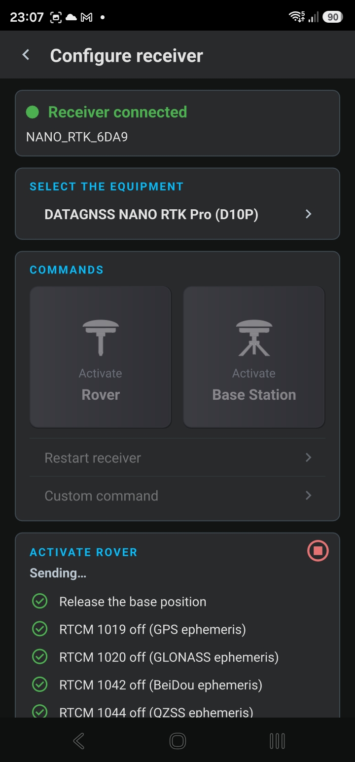
On the GNSS page, the blue Configure receiver button opens the NANO’s configuration screen. Under SELECT THE DEVICE the app already picks DATAGNSS NANO RTK Pro (D10P) when it recognizes the receiver by its Bluetooth name or USB port. If another name shows up, tap it and choose the NANO from the list.
The COMMANDS box has two buttons and two lines:
| Command | What it does |
|---|---|
| Activate Rover | Returns the NANO to normal mode: free position, 1 Hz, the messages the app uses. This is the factory default, saved in the receiver. |
| Activate Base Station | Locks the NANO’s position to a known point and makes it output corrections for other receivers. Requires signing in. |
| Restart the receiver | Restarts the NANO without erasing its configuration. Rarely needed. |
| Custom command | Sends whatever you type to the receiver, as is. Only for those who know the manufacturer’s protocol: a wrong command can leave the receiver unusable. |
Sending is immediate, with no confirmation: a tap on Activate Rover is undone by Activate Base Station, and vice versa. The app configures the NANO only over Bluetooth or USB. The NANO’s own Wi-Fi features are not used by TrackMaker and are a matter for the manufacturer’s support.
Activate Rover
Use it when:
- the NANO was used as a base station and is going back to measuring;
- the receiver was configured by another program and no longer behaves as before;
- the GNSS page shows the red Position is not changing card.
Tap Activate Rover. The app sends the commands (about 12 seconds), shows Done. Saved to the receiver and restarts positioning. The receiver goes silent for a few seconds (Connected, receiver silent) and comes back on its own, with a fresh position in about 15 seconds.
Activate Base Station
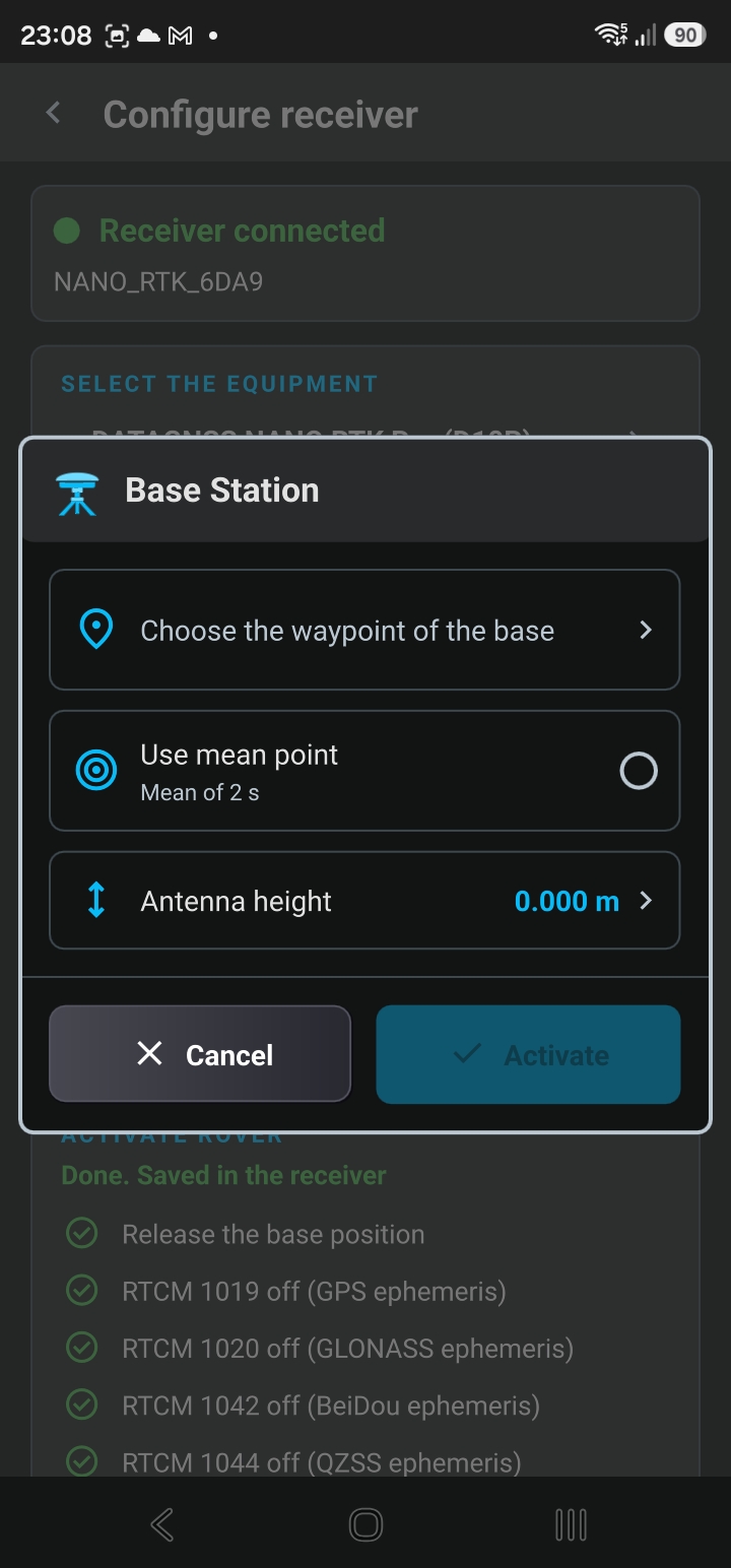
With two receivers, one of them can be your team’s base: it stays still over a point, generates corrections, and the app broadcasts them over the internet, through TrackMaker’s servers, to the other phones on your account. No radio, no computer and no need for a public station nearby.
What the base needs: the NANO set up over the point (tripod or fixed pole, open sky, antenna level), powered by a power bank, and a phone next to it, connected to the NANO over Bluetooth, with internet and signed in to the PRO account. That phone is dedicated to the base: it cannot work as a rover while it broadcasts.
- Mark the base point as a waypoint beforehand, if you already have its coordinates (from a previous RTK FIXED survey, from a benchmark, etc.).
- With the base NANO connected, open GNSS, Configure receiver and tap Activate Base Station.
- In the Base Station window, under Choose the base waypoint, tap Select the waypoint. The list shows the waypoints with their distance to the receiver, closest first. The waypoint must be less than 50 m from the receiver.
- Without a known point, check Use average point. The app averages the receiver’s position while the window stays open (Averaging 59 s). Allow at least one minute.
- Enter the base’s Antenna height (from the point to the antenna, on the tripod).
- Tap Activate. The app sends the commands (about 8 seconds) and opens the Base Station page.
- Under BASE NAME, give it a short name (letters and digits, up to 20): this is how the base shows up on the other phones. Tap Start.
- The card changes to ON AIR, with the broadcast time, satellites, send rate, total sent and the number of connected rovers. Right below, the signal bars and the send chart for the last 5 minutes.
On the team’s other phones (same account): menu ☰, Online Correction, MY BASE STATIONS box, tap the base and then Connect. The panel says Base station NAME and the solution goes to RTK FIXED just like with any server.
Known point or average point?
- Waypoint with known coordinates: everything you measure comes out in its true position, with absolute centimeter accuracy.
- Average point: the average carries the error of an uncorrected position (a few meters), but everything you measure from it is consistent with itself to centimeter accuracy. It works for relative surveys: areas, distances, alignments. The app saves the average as a waypoint (BASE STATION1, BASE STATION2…) and, the next day, opens the window with that same point. Use it again, never a new average, so that the days line up.
Rules for using the base:
- The broadcast lives on the Base Station page. The screen can turn off and the phone can go in your pocket. Leaving the page (arrow or Back button) ends the broadcast, after a confirmation.
- When stopping, the app asks Switch the GNSS configuration back to Rover?. Answer Yes – Recommended: the NANO returns to normal mode right away. If you answer No, it keeps its position locked.
- While it is a base, that phone’s map panel shows No fix and the GNSS page says Position is not changing. That is expected: the base position is fixed.
- The service is for field work, not for a permanent station. The base shuts itself off after 12 continuous hours and after 10 minutes without corrections from the receiver.
- Base and rover are different receivers. The same NANO cannot do both at once.
Note, NANO-specific behavior: if the base receiver is powered off (power bank drained, cable loose), when powered back on it does not resume broadcasting and stays with its position locked at the base point. Go back to Configure receiver, tap Activate Base Station again (the point and the height are kept) and then Start. And before using that NANO as a rover, tap Activate Rover.
Common issues
| What you see | Likely cause | What to do |
|---|---|---|
| Red No GNSS data card with Receiver not found | NANO without power, out of range or connected to another phone. | Check the power bank and the distance. The app reconnects on its own when the receiver comes back. |
| The NANO does not show up in Search for receivers | Bluetooth off, permission denied, or the NANO already connected to another device. | Turn on Bluetooth, allow access when the app asks, power the NANO off and on and search again. |
| Connected, receiver silent (USB) | Port B chosen, or speed other than 230400. | Choose port A and check the Speed (baud). |
| Position is not changing (red card, panel at NO FIX) | The NANO has its position locked from a previous use as a base. | Configure receiver and Activate Rover. |
| Stays in RTK FLOAT and never reaches FIXED | Obstructed sky, antenna low or close to your body, station too far away, or corrections not arriving (Age climbing). | Move to open sky, raise the antenna, check the internet and the Age, choose the closest station and wait 1 to 5 minutes. |
| RTK FIXED with V above 10 cm, or the position jumps by tens of centimeters | Under a roof, trees or near walls the NANO may lock onto a wrong solution. | Be suspicious of a FIXED with a large V. Move to open sky and wait for the solution to refix before measuring. |
| Username or password rejected | Wrong correction server credentials, or registration not yet active. | Check the username and password of your account with the correction provider. |
| Mount point not found on the server | The chosen station went offline. | Edit the server and choose another station with the button next to Mount Point. |
| Service unavailable on the server | The server is down at the moment. | Try again later. Do not keep reconnecting. |
| Altitude very different from what you expected | The app uses the ellipsoidal height, not sea level; or the antenna height is wrong. | Check Antenna height. The difference from sea-level altitude is normal. |
If you need help, record a log: on the GNSS page, open Log, turn on Save log to file, reproduce the problem and use Share to send the file to support. The log contains only what the receiver sent.
Summary in ten steps
- Antenna on the pole, NANO on the power bank, antenna height written down.
- Menu ☰, GNSS, Bluetooth receiver card, Search for receivers, tap the NANO.
- Green Receiving GNSS data card.
- Antenna height in the EXTERNAL RECEIVER box.
- Sign in with the PRO account.
- Menu ☰, Online Correction, +, your correction provider, username, password and the closest station.
- Connect, and wait for the panel to show RTK FIXED in green.
- Mark waypoints and record tracks standing still over the point, with the pole vertical.
- For your own base: Configure receiver, Activate Base Station, waypoint or average point, name, Start. On the rovers: Online Correction, MY BASE STATIONS.
- When done with the base: Stop and Yes – Recommended so the NANO goes back to rover.
Still have questions? Reach us through the contact page.