
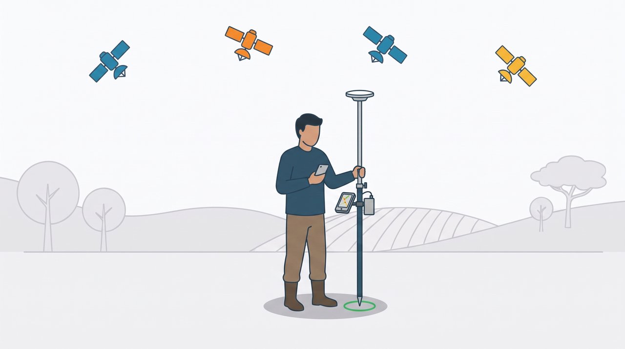
Understand how an RTK receiver connected to your phone gets down to 1 to 3 centimeters of error, and why it depends on a correction received in real time
If you use a handheld GPS, like the Garmin ones, you know the routine: turn the device on, wait for the satellites, mark the point. The error is around 3 to 5 meters, and for trails, navigation and a lot of field work that is enough.
Version 2.0 of GPS TrackMaker for Android brought another category of accuracy: RTK, which takes the error down to 1 to 3 centimeters. But RTK does not work like a handheld GPS. The receiver, by itself, does not deliver the centimeters. It needs to receive, every second, an extra piece of information called a correction.
This page explains, without formulas, what RTK is, where the correction comes from and what you need to use all of this with GPS TrackMaker.
Why ordinary GPS is off by a few meters
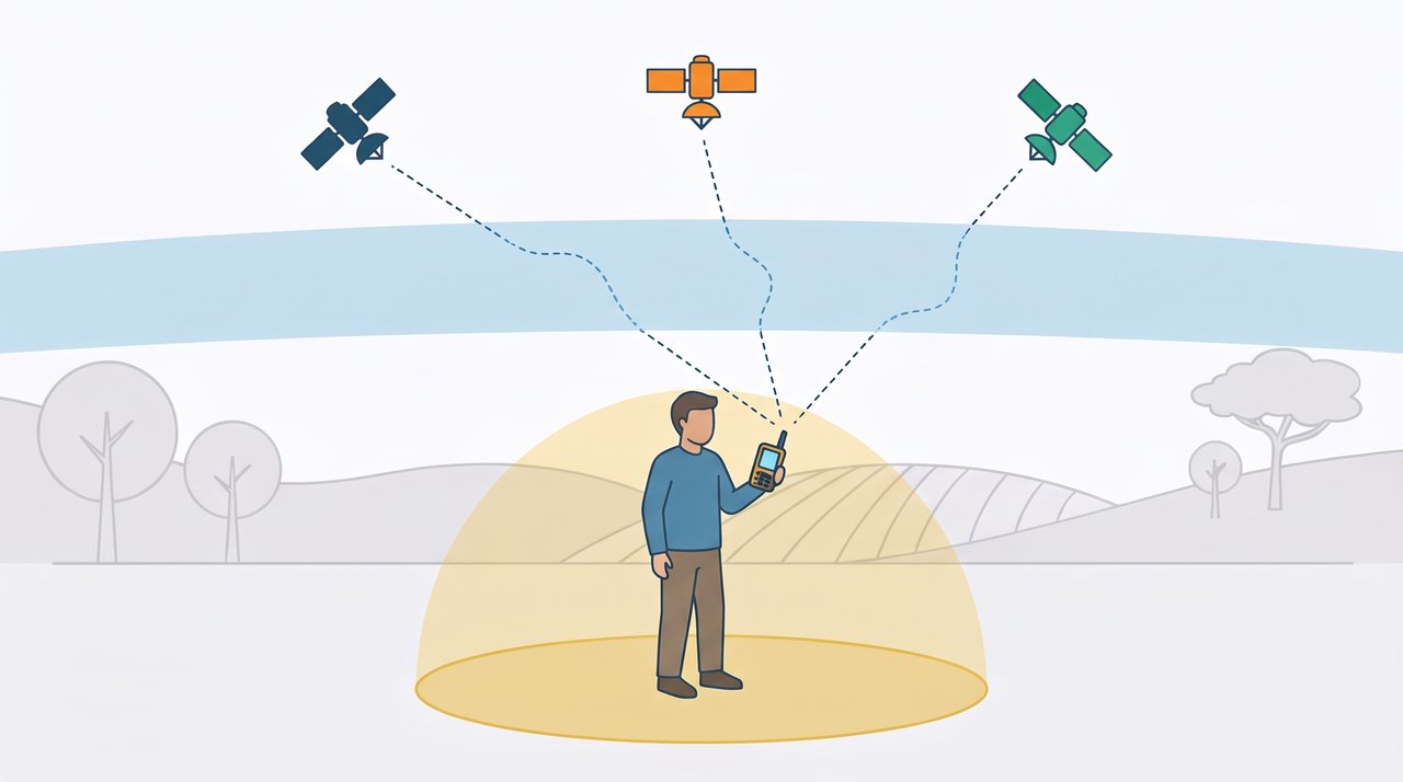
The receiver calculates its position by measuring the distance to several satellites. Each satellite’s signal travels more than 20,000 kilometers and, on the way, crosses the atmosphere, which delays it in a way that changes all the time. Add to that small errors in each satellite’s clock and orbit.
The result is that each measured distance arrives with a few meters of error, and so does the calculated position. This is true for a handheld GPS, for a phone and for any receiver working alone. It is not a defect or a lack of adjustment: it is the limit of the method.
The idea behind RTK: two receivers seeing the same error
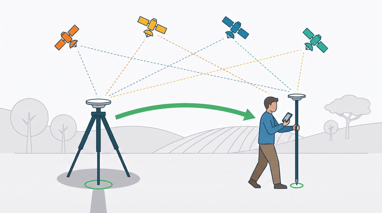
Imagine a second receiver, standing still over a point whose coordinate is known exactly. Because it knows where it is, it can tell how much each satellite’s signal is wrong at that instant.
Now comes the detail that makes everything work: a receiver a few kilometers away receives the same satellites, through practically the same atmosphere. It suffers almost the same errors. If the stationary receiver tells the other one what it is measuring, the other can cancel those errors and calculate a much better position.
That is RTK, short for Real Time Kinematic:
- The base is the stationary receiver on the known point.
- The rover is the receiver that moves with you, on the pole.
- The correction is what the base sends to the rover, once per second.
RTK receivers also make a much finer measurement of the signal than ordinary receivers. Putting the two together, the error drops from meters to 1 to 3 centimeters.
The part that surprises people coming from handheld GPS
Without a correction there is no RTK. An RTK receiver without a correction is just a good GPS with a few meters of error. Buying the receiver is half the way. The other half is having somewhere to get the correction from.
And the correction has to arrive in real time, nonstop. Traditionally it came by radio, from a base set up by the user. Today it comes over the phone’s internet connection: the phone receives the correction from a server and passes it on to the receiver, by Bluetooth or by cable.
In GPS TrackMaker this feature is called Online Correction. (The technical name of this system is NTRIP, and you will find it in the forms and documentation of correction services.)
So, to work with RTK, you need three things:
- An external RTK GNSS receiver. The phone’s internal GPS does not use corrections, and neither do ordinary handheld GPS units.
- A phone with internet and GPS TrackMaker.
- A correction source.
Where the correction comes from: three paths
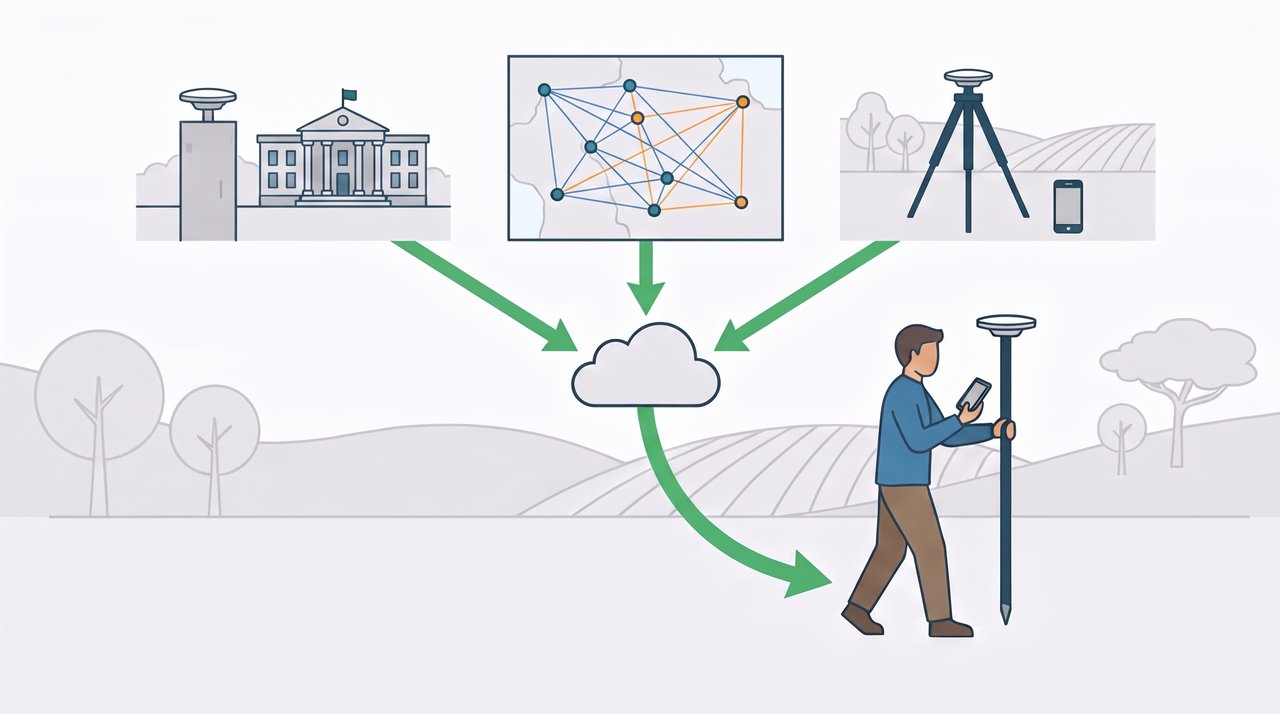
1. Public networks (often free)
In many places, government agencies keep networks of permanent GNSS stations and broadcast their corrections over the internet, often free of charge. You register on the operator’s website, receive a username and password and choose the station closest to where you will work.
In the United States there is no single nationwide service. Real-time networks are run state by state, usually by the Department of Transportation (DOT). Many are free and only ask for registration, such as Florida’s FPRN, run by the Florida DOT, and New York’s NYSNet, run by the New York State DOT. Other states, such as Minnesota, Ohio and Oregon, run similar networks, and some states charge a fee. Look for your state’s real-time GNSS network (RTN).
In Canada there is no free nationwide service. RTK corrections come mostly from commercial subscription networks (the second path, below), many of them validated by Natural Resources Canada (NRCan) against the national reference frame.
In GPS TrackMaker, you add a public network through the Enter manually option of Online Correction, with the data from your registration: address, port, mount point, username and password.
With a single station, the limitation is distance. A station’s correction is valid for the region around it. The farther away, the slower and less accurate the solution. Up to about 30 km it works well. Beyond 50 km, it may not reach centimeters. Many public networks also offer the virtual base described below, which avoids this limit.
2. Private networks (by subscription)
Companies maintain their own station networks and sell access, by the month or by the hour of use. Many offer what is called a virtual base: the server calculates a correction tailored to the place where you are, and the accuracy holds across the whole area covered by the network. It is the way to go for those who work far from public stations.
In GPS TrackMaker, any service of this kind goes in through the Enter manually option of Online Correction, with the data the provider gives you: address, port, mount point, username and password.
3. Your own base
With two receivers, one of them can be your base. It stays still over a point, and GPS TrackMaker transmits its correction, over the internet, to the phone that is with the other receiver. No radio and no computer.
It is the solution for when there is no station nearby, or for those who want to work without depending on third parties. It requires two receivers and two phones on the same account (see Your own base with the GPS TrackMaker Double Pack license, further down).
Comparing
| – | Public network | Private network | Own base |
|---|---|---|---|
| Cost of the correction | Often free | Subscription | None, besides the second receiver |
| Where it works | Near a station | In the area covered by the network | Wherever you set up the base |
| Receivers needed | 1 | 1 | 2 |
| Phones needed | 1 | 1 | 2 |
| Internet in the field | Yes | Yes | Yes, on both phones |
Note: some receivers get a type of correction straight from satellite, without internet, called PPP. The accuracy is decimeters, not centimeters, and it takes from several minutes to an hour to settle. GPS TrackMaker shows this solution with the PPP label. It is an alternative where there is no cell signal, but it is not RTK.
What you need to get started
| Item | Notes |
|---|---|
| External RTK GNSS receiver | The models we tested with GPS TrackMaker are on the Approved GNSS Receivers page. |
| Android phone with GPS TrackMaker 2.0 or newer | On iPhone, the app still uses only the internal GPS. |
| GPS TrackMaker PRO account | Connecting the receiver to the app is free. Online Correction and Base Station require signing in with a PRO account. |
| Internet at the work site | Over the cellular network or, where there is no signal, over the Wi-Fi of a satellite internet antenna, such as Starlink. Data use is low: 3 to 6 MB per hour. |
| A correction source | Public network, private network or your own base. |
| Pole and open sky | The antenna needs to see the sky. Under trees, under roofs and next to walls, RTK does not hold. |
How RTK shows up in GPS TrackMaker
The flow in the app has three steps:
- Choose the receiver. Menu (☰), GNSS, and the receiver by Bluetooth or by USB cable. The app starts using its position instead of the phone’s GPS.
- Turn on the correction. Menu (☰), Online Correction, choose the server and tap Connect.
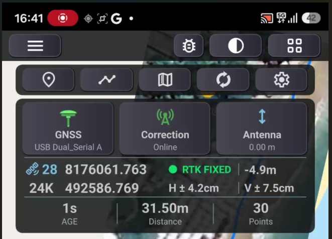
- Watch the panel. The GNSS RTK panel, on the map, shows the quality of the position every second.
The panel is where you see RTK happen. The label changes as the solution improves:
| Label | What it means | Typical error |
|---|---|---|
| SINGLE (yellow) | Receiver alone, without correction. Meter-level error, as with a handheld GPS. | 2 to 3 m |
| RTK FLOAT (orange) | The correction has arrived and the receiver is refining the solution. | Decimeters |
| RTK FIXED (green) | Centimeter solution. This is the one that counts for measuring. | 1 to 3 cm |
Next to the label, the panel shows the horizontal and vertical accuracy reported by the receiver (±H and ±V), the number of satellites and the Age, the age of the correction in seconds. An Age of 1 or 2 seconds means the correction is arriving normally. If it starts to climb, the correction has stopped, and the solution gradually falls back to SINGLE.
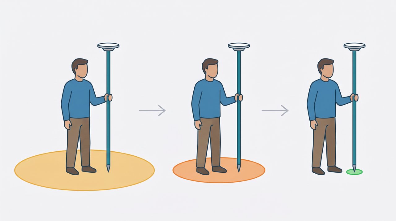
In open sky, with a station nearby, going from SINGLE to RTK FIXED takes from a few seconds to a few minutes.
The rest you already know. Waypoints and tracks are recorded the same way, only with the RTK receiver’s position. Each waypoint marked in RTK gets a comment line with the solution, the accuracy, the satellites and the antenna height at that instant. Everything goes to GPS TrackMaker Desktop through Synchronization or by GTZ file.
Your own base with the GPS TrackMaker Double Pack license
To be your own correction source you need two sets:
- Base: a receiver standing over a point, on a tripod, with a phone next to it.
- Rover: the other receiver on the pole, with the other phone, moving around the job.
Both phones need to be signed in to the same account, because an account’s base is visible only to that account’s rovers. That is what the GPS TrackMaker PRO Double Pack license is for. It covers 2 Windows computers and 2 smartphones on the same account. One phone stays with the base, the other with the rover.
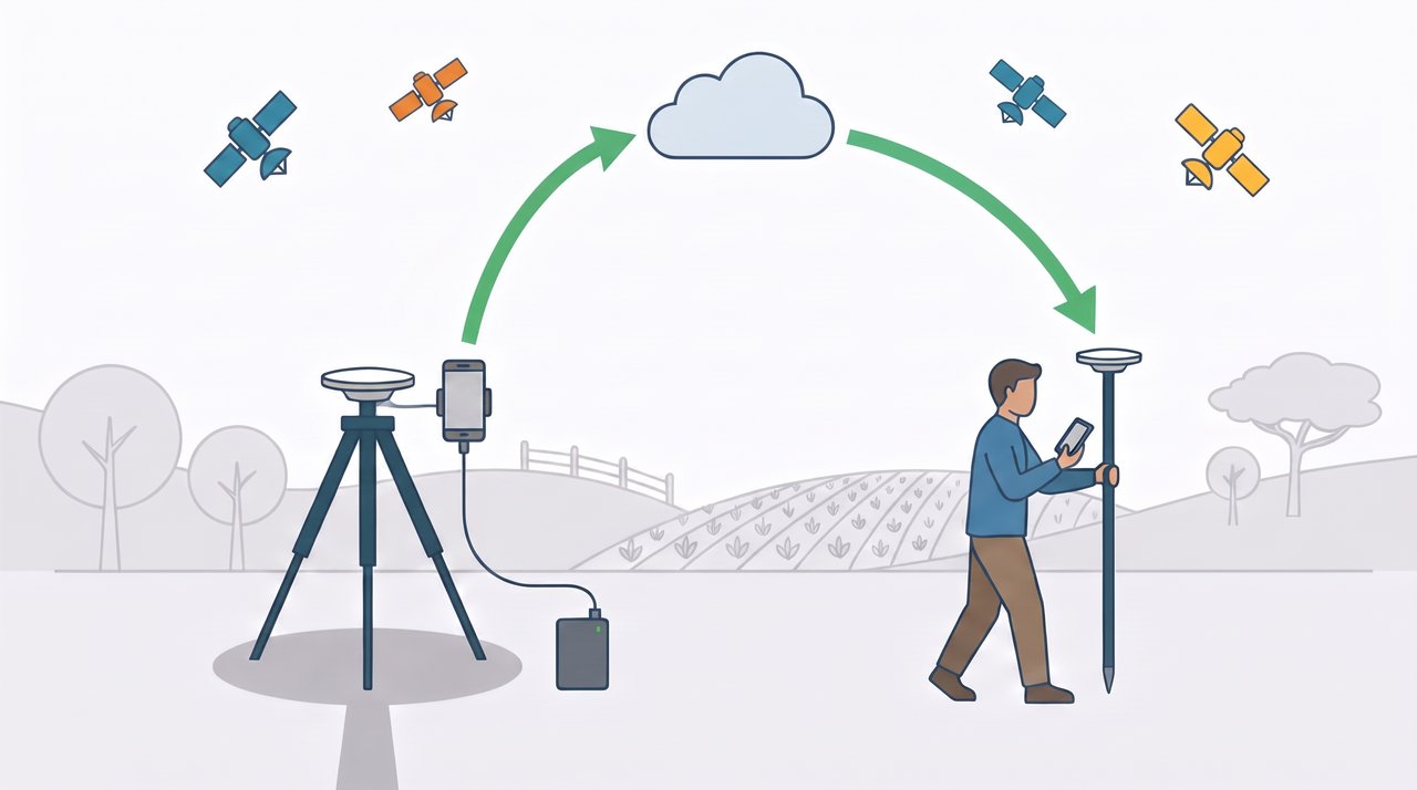
In short, on the base phone:
- Menu (☰), GNSS, Configure receiver button, Activate Base Station button.
- Choose the waypoint of the point where the base is, or Use average point if you do not have that point’s coordinate.
- Give the base a name and tap Start. The page shows ON AIR.
On the rover phone:
- Menu (☰), Online Correction.
- In the MY BASE STATIONS box, tap your base and then Connect.
The complete walkthrough, screen by screen, is on each receiver’s page, starting from the list of Approved GNSS Receivers.
Three things to know about running your own base:
- Known point or average point. If the base sits on a point with a known coordinate, everything the rover measures comes out in its true position. That point can be a waypoint you marked earlier in RTK FIXED, using another correction source, such as a public network (NTRIP). If you use the average point, the base assumes an approximate coordinate (with meters of error), but everything the rover measures stays consistent with each other to centimeter accuracy. For measuring areas, distances and alignments, the average point does the job.
- Both phones need internet. The correction travels over the internet, from the base to the rover. Without a connection on either one, there is no correction.
- It is a service for field work. The base shuts down by itself after 12 hours straight on air. It is not meant to be a permanent station.
Not every receiver can work as a base. The Approved GNSS Receivers page shows which ones can do both jobs.
Limits and precautions
RTK is accurate, but it is demanding. It pays to know the limits before trusting the centimeters.
- Open sky. A handheld GPS works under trees, with a larger error. RTK does not: under dense canopy, under roofs or next to buildings the solution drops to FLOAT or SINGLE or, worse, may stay in FIXED while locked onto a wrong position. Measure with a clear sky.
- Distance from the base. The error grows by about 1 cm for every 10 km between the rover and the station that sends the correction.
- Internet. Without internet there is no correction. Check the cell coverage at the site before planning the job. Where there is no signal, you can still use RTK with a satellite internet antenna, such as Starlink: the phone connects to the antenna’s Wi-Fi, and GPS TrackMaker receives the correction and passes it on to the receiver in the same way. You just need to keep the phone within range of that Wi-Fi.
- Only measure in RTK FIXED. Wait for the green label, with the pole still and vertical. A point marked in FLOAT may be off by decimeters.
- The reference frame comes from the base. The coordinate you get is in the reference frame of the station that sends the correction. Most networks in the United States and Canada work in NAD 83, and stations in Brazil work in SIRGAS2000. Other services may use a different frame, and the difference between them can go from tens of centimeters to more than a meter. Do not mix correction sources in the same job.
- The altitude is ellipsoidal. The app shows and records the height calculated by the receiver, with the antenna height already subtracted. It differs from the altitude above sea level by several meters or more. Always enter the correct antenna height.
- Check on a known point. Whenever you can, start the day by measuring a point with a known coordinate. It is the best proof that receiver, correction and antenna height are right.
Note: work with legal requirements, such as property boundary surveys, has its own rules for method, equipment and professional responsibility. RTK in GPS TrackMaker is a field tool. It does not replace a licensed professional or exempt you from those rules.
Short glossary
| Term | Meaning |
|---|---|
| GNSS | Generic name for satellite positioning systems: GPS, GLONASS, Galileo, BeiDou. |
| RTK | Technique that uses a base’s correction to reach centimeters, in real time. |
| Base | Stationary receiver on a known point, which generates the correction. |
| Rover | Receiver that moves, and that receives the correction. |
| Correction | Data the base sends to the rover, every second. |
| NTRIP | Technical name of the system that delivers the correction over the internet. In the app, Online Correction. |
| Mount point | Name of each station or correction stream within a server. |
| SINGLE, RTK FLOAT, RTK FIXED | The solution levels: no correction, converging and centimeters. |
| Age | Age of the correction in seconds. Normal: 1 to 2 s. |
| PPP | Correction received by satellite, without internet. Decimeter accuracy. |
| NAD 83, SIRGAS2000 | Official reference frames of North America and of Brazil. Your coordinates come out in the frame used by the network that sends the correction. |
Next steps
To choose a receiver, see the Approved GNSS Receivers page. It lists the models we tested with GPS TrackMaker and leads to the walkthrough for each one.
Still have questions? Reach us through the contact page.